


From Orbit to Action: AI for Earthquake Response
🏆 The winners of the AI for Earthquake Response Challenge have been determined 🏆
The ESA Φ-lab Challenge: AI for Earthquake Response has officially concluded, and we are proud to announce the winning teams!
This international Challenge invited innovators, researchers, and developers to design AI-driven solutions to support earthquake response efforts. In the challenge’s educational framework, participants were asked to process Earth observation data with advanced machine learning methods to provide accurate and timely assessments that can aid disaster response.
The evaluation followed the challenge rules, combining the F1 score of Phase 1 (40%) and Phase 2 (60%) to determine the final ranking:
🥇 TelePIX: 0.7066794
🥈 Datalayer: 0.6697664
🥉 DisasterM3: 0.6597626
🏅 Badaboum: 0.6469298
We congratulate all winners on their remarkable achievements! Their solutions demonstrated robust technical performance and showcased the potential of AI to play a critical role in supporting emergency response and decision-making. The winning teams will have the opportunity to present their solutions during the Board Meeting of the International Charter ‘Space and Major Disasters’, in Strasbourg on 08 October 2025.
We would also like to thank all participating teams for their creativity, commitment, and collaborative spirit.
🏙️The Challenge
Earthquakes strike suddenly and unpredictably, often causing widespread destruction to infrastructure, buildings, and essential services – putting lives at risk in an instant. In the critical hours following such an event, speed is everything. Rapid damage assessments can guide emergency responders to the hardest-hit areas, help identify ongoing risks, and support life-saving decisions when time is of the essence.
Earth Observation (EO) plays a vital role in crisis response by providing timely, accurate, and actionable insights. The International Charter ‘Space and Major Disasters‘ facilitates rapid access to satellite imagery following disasters, enabling responders to assess the full extent of damage from space. Through its global network of space agencies and satellite operators, the Charter delivers critical EO data within hours of an event to support rescue and recovery efforts.
Yet, despite access to high-resolution satellite imagery, damage mapping still relies heavily on human interpretation – a process that takes time, especially when every minute matters. Automating this process with artificial intelligence (AI) offers the potential to dramatically accelerate disaster response, generating actionable insights within minutes rather than hours.
But creating reliable AI for real-world disaster scenarios is no easy task. Models must be highly accurate, fast, and resilient to noisy, complex inputs. That’s where you come in.
Together, the ESA Φ-lab and the International Charter ‘Space and Major Disasters’ invite data scientists, AI researchers, students, geologists, and developers from around the world to join the AI for Earthquake Response Challenge – to build machine learning models capable of rapidly identifying post-earthquake building damage using EO data.
This is your chance to contribute to future innovation of humanitarian and disaster relief effort – using AI to help save lives when it matters most.
🛰️ The mission
In the aftermath of a major earthquake, precision and speed are essential. Satellite imagery offers a unique vantage point to assess damage at scale – if paired with intelligent analysis.
This challenge tasks you with developing state-of-the-art AI models that can automatically detect damaged vs. undamaged buildings by analyzing high-resolution pre- and post-event satellite imagery.
The AI for Earthquake Response Challenge is a research-driven initiative that complements, but operates independently from, the Charter’s operational framework. Leveraging historical data from past activations, the Challenge aims to explore innovative approaches to rapid, automated impact assessment. High-performing solutions may inform the future evolution of the Charter’s operational processing chain, particularly within ESA’s cloud-based EO environment, the Charter Mapper.
💡The data
Don’t worry, you’re not alone. The ESA Φ-lab and the Charter will provide exclusive access to a curated archive of multi-mission, high-resolution satellite imagery collected from previous Charter activations. The dataset includes pre- and post-event imagery from satellites such as BlackSky Global, Gaofen-2, GeoEye-1, Kompsat-3 & 3A, Pléiades-1, WorldView-2, and WorldView-3.
All data is processed through the ESA Charter Mapper and will be made available via the Earth Observation Training Data Lab (EOTDL).
⚠️ Please note that some data used in the dataset are subject to access restrictions and require us to grant you access manually.
🏆The reward(s)
This challenge is not only about advancing science – it’s about real-world impact. Winning models will gain visibility in open-science forums and may be considered for integration into the ESA Charter Mapper, potentially becoming key tools used in future disaster response missions.
-
🥇 1st Prize: €3,000
-
🥈 2nd Prize: €2,000
-
🥉 3rd Prize: €1,000
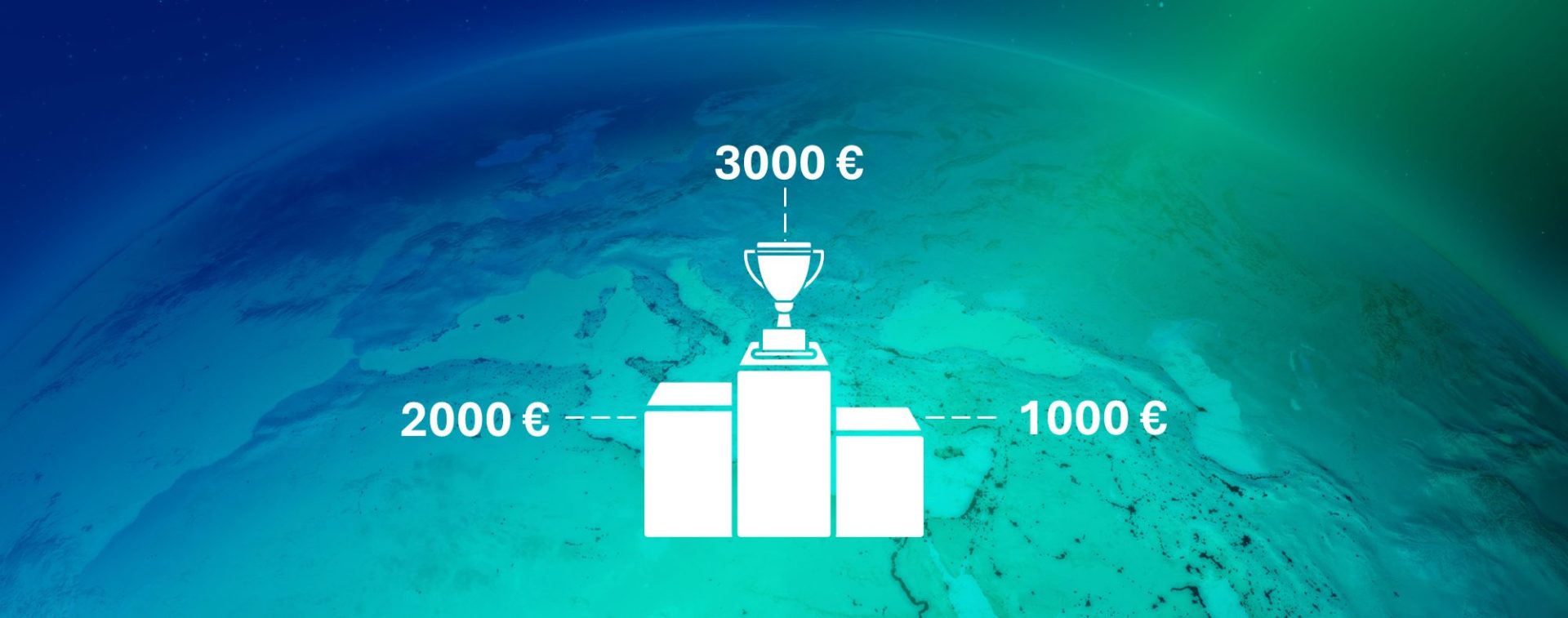
Each winning team is also eligible for up to €500 in travel reimbursement to attend the 54th Charter Meeting in Strasbourg (06–10 October 2025).
Your work will be visible to leaders in the global space, humanitarian and disaster response community – and might one day help save lives on the ground.
📋 At a glance
Still on the fence? Here’s what you’ll gain:
🚀 Make a tangible impact on real-world disaster response
🔬 Collaborate with top experts and institutions in space and AI
📡 Access exclusive EO datasets used in international operations
🌍 Showcase your work to space agencies and humanitarian stakeholders
💡 Push the boundaries of applied AI for good
So, just keep in mind the key dates:
- 🟡 Pre-launch (open for registrations): 20 June 2025
- 🔵 Full launch of phase 1 (dataset access): 11 July 2025
- 📖 Introductory webinar: 29 July 2025
- 🔵 Phase 1 closing: 05 September 2025, 15:00 CEST
- 🔵 Phase 2 launch: 05 September 2025, 17:00 CEST
- 🕓 Submission deadline: 15 September 2025, 17:00 CEST
- 🏅 Winners announced and ceremony: 06–10 October 2025 (Charter Meeting in Strasbourg)
Whether you’re joining solo, forming a team, or looking for collaborators – everyone is welcome.
Start building, start coding, and help us shape the future of disaster response.
Join now: https://platform.ai4eo.eu/ai-for-earthquake-response
We would like to thank the Earth Science Informatics Technical Committe (ESI TC) of the Institute of Electrical and Electronics Engineers (IEEE) for their support in advertising this Challenge

Make a real-world Impact
Your model could directly support emergency responders by helping identify damaged buildings faster – saving lives when every second counts after an earthquake.
Access exclusive EO data from real-life events
Work with high-resolution satellite imagery from actual past Charter activations and gain access to an exclusive library of data.
Collaborate, innovate, and gain recognition
Join a global community of researchers, receive support from ESA and CNES data scientists, and gain the recognition of a global community.
The winners of the AI for Earthquake Response Challenge are:

Winner
TelePIX

2nd
Datalayer

3rd
DisasterM3